
Rastreo de las Vías de Dispersión de Metales en un Paisaje Minero Mediterráneo Abandonado: Caso de Estudio del Distrito Minero de Cartagena–La Unión.
El antiguo distrito minero de Cartagena-La Unión (sureste de España) es uno de los paisajes mineros más afectados de la cuenca mediterránea. El área ha sido explotada durante más de dos milenios por minerales sulfurados como galena (PbS), esfalerita (ZnS) y pirita (FeS), así como carbonatos, óxidos de hierro, hidróxidos y sulfatos. La actividad minera alcanzó su punto álgido desde mediados del siglo XIX hasta 1991, año en que cerró la última mina. Hoy en día, el paisaje conserva numerosas huellas de su pasado minero, incluyendo millones de toneladas de residuos mineros con concentraciones extremadamente altas de metales (p. ej., Pb y Zn frecuentemente > 10 000 mg kg⁻¹, Cu comúnmente > 100 mg kg⁻¹, Mn a menudo > 1 500 mg kg⁻¹, y Cd entre 10 y 100 mg kg⁻¹). Combinados con una escasa cubierta vegetal, eventos de lluvias torrenciales y vientos persistentes, estas condiciones crean un sistema altamente dinámico donde tanto erosión hídrica y eólica actúan como vías principales para el transporte de contaminantes.
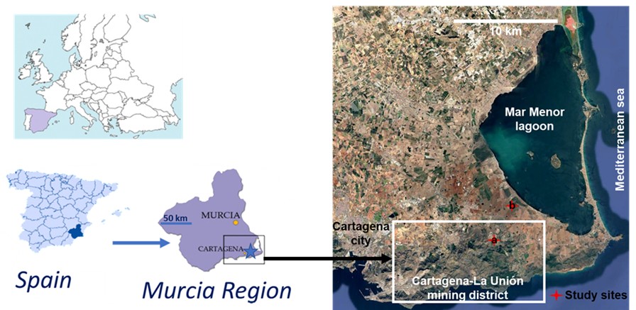
Figura 1. Ubicación del distrito minero Cartagena–La Unión (SE de España) y sitio de estudio donde se está implementando la recolección de datos SOILPROM para la erosión hídrica (a) y la erosión eólica (b).
Dentro del proyecto Horizon Europe SOILPROM, este sitio sirve como un caso de uso clave para comprender cómo los metales y metaloides son transportados y redistribuidos en condiciones ambientales reales. Nuestro trabajo se centra en una pregunta central: ¿Cómo impulsan los procesos de erosión la dispersión de metales en áreas mineras abandonadas semiáridas?
Erosión hídrica: Eventos de tormenta como impulsores del transporte de metales
La Rambla del Beal, un cauce efímero que drena la zona minera, juega un papel clave en el transporte de metales. Su cauce, muy afectado por los residuos mineros, actúa como un importante conducto para la transferencia de sedimentos contaminados a las zonas bajas.
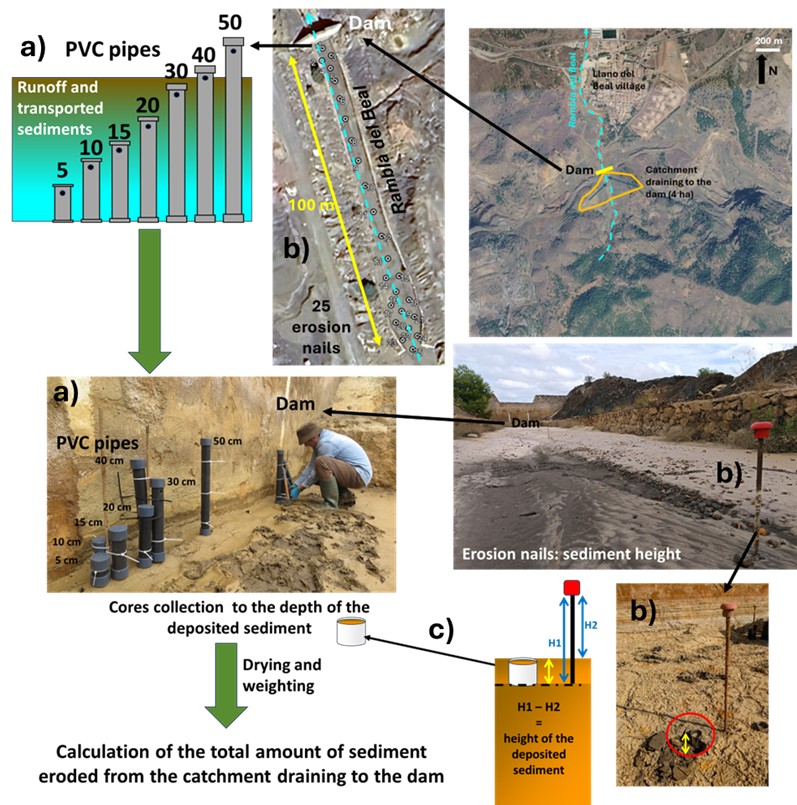
Para cuantificar el transporte de sedimentos contaminados por la erosión hídrica, se ha establecido un seguimiento de campo a lo largo de un tramo de ~1.5 km de la sección superior de la Rambla del Beal, centrándose en una presa de control.
El enfoque combina:
- Colectores de escorrentía (tuberías de PVC) para capturar la escorrentía y los sedimentos en suspensión
- Uñas de erosión para medir la deposición de sedimentos en el lecho del agua
- Muestra de sedimento muestreo para cuantificar la cantidad de material acumulado en el lecho acuático
- Análisis a escala de cuenca (pendiente, vegetación, propiedades del suelo)
Figura 2. Vista panorámica de las laderas de la cuenca hidrográfica que desemboca en la Rambla del Beal, donde se han instalado clavos de erosión para evaluar la deposición de sedimentos en el lecho del río y se han colocado tubos de PVC junto a la presa de contención para recoger la escorrentía y los sedimentos en suspensión.
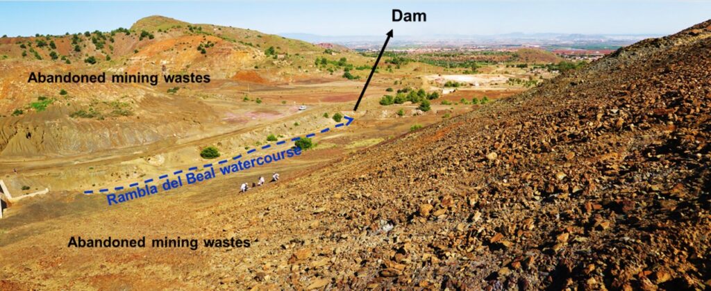
Figura 3. Detalles de los tubos de PVC (a) para la recogida de escorrentía y sedimentos en suspensión, clavos de erosión (b) y muestreo de sondeos (c) en el cauce de la Rambla del Beal.
Se supervisaron cuatro eventos de escorrentía y erosión entre el verano de 2025 y la primavera de 2026. En verano, la sequedad extrema del suelo favorece la oxidación de los sulfuros contenidos en los residuos mineros, lo que da lugar a la precipitación de sulfatos metálicos secundarios en la superficie (Figura 4). Cuando estos sulfatos se disuelven durante los eventos de lluvia, la escorrentía resultante es muy salina y ácida, lo que facilita el transporte de metales disueltos (Figuras 5 y 6).
Figura 4. Eflorescencias salinas formadas por sulfatos secundarios precipitados durante los periodos más secos del año.
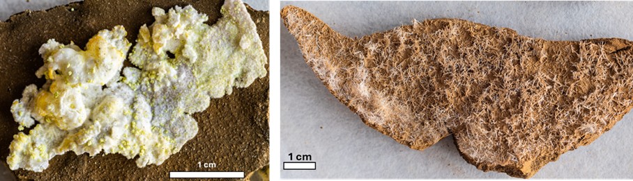
Figura 5. Conductividad eléctrica (CE) y pH de las aguas de escorrentía recogidas entre julio de 2025 y abril de 2026.
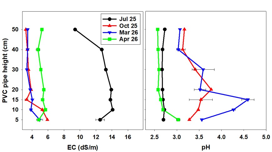
Figura 6. Concentraciones de metales solubles en las aguas de escorrentía recogidas entre julio de 2025 y octubre de 2025.
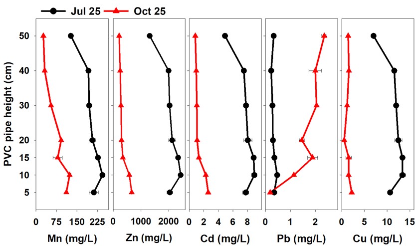
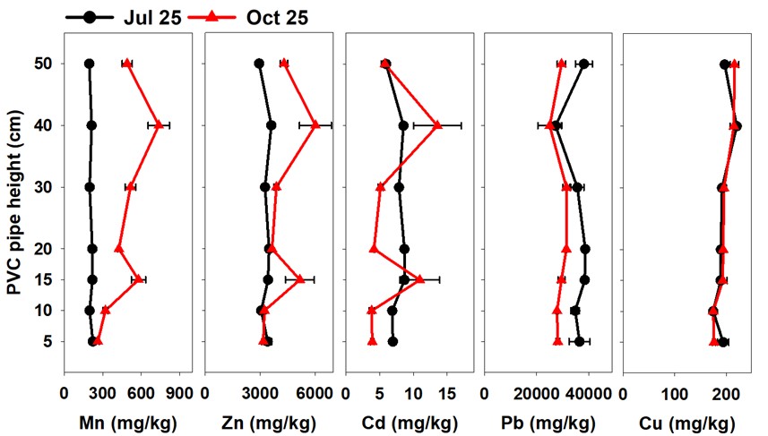
Las tasas de erosión oscilaron entre 0,5 y 1,7 t ha⁻¹ (figuras 7 y 8) y los sedimentos transportados contenían concentraciones muy elevadas de metales (p. ej., Pb: 20 000–40 000 mg kg⁻¹; Zn: 3 000-6 000 mg kg⁻¹) (Figura 8).
Figura 7. Medición de la altura del sedimento en los clavos de erosión después del evento de lluvia de octubre de 2025.
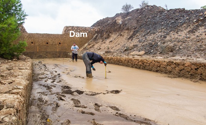
Figura 8. Tasas de erosión en los eventos monitoreados entre julio de 2025 y abril de 2026.
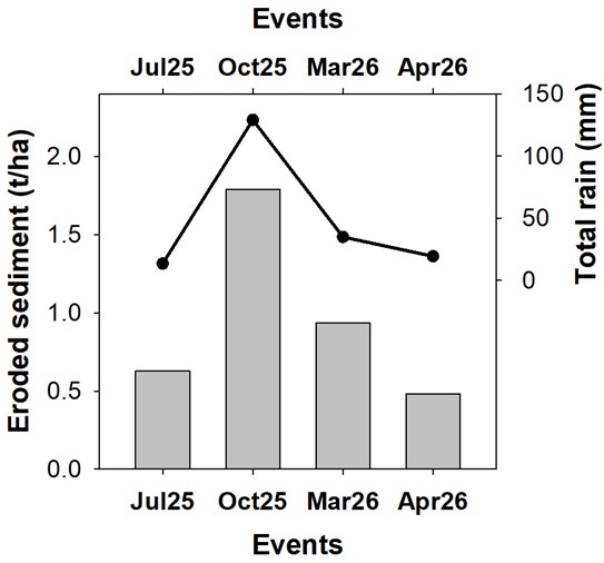
Figura 9. Concentraciones totales de metales en los sedimentos recogidos en las tuberías de PVC tras las precipitaciones de julio de 2025 y octubre de 2025.
La erosión hídrica es una vía importante para la dispersión de metales, actuando de dos maneras:
1) el transporte de metales disueltos en las aguas de escorrentía;
2) el transporte de metales ligados a las partículas del suelo. La dispersión de metales por la erosión hídrica presenta un marcado carácter estacional debido a la formación de eflorescencias de sulfato durante el período seco del verano.
Erosión Eólica: Vías Atmosféricas de Contaminación
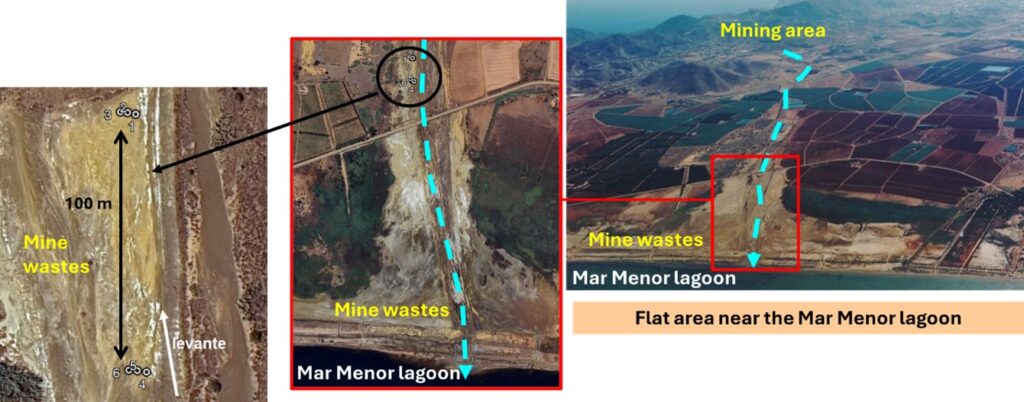
Paralelamente, se están investigando los procesos eólicos en una zona de deposición llana situada a unos 6,5 km de distancia, cerca de la desembocadura de la Rambla del Beal, donde se han acumulado residuos mineros a lo largo de décadas (Figura 10).
Figura 10. Ubicación de la zona llana para evaluar el transporte de metales por erosión eólica.
El montaje experimental incluye:
- Recolectores de polvo BSNE (Big Spring Number Eight) en múltiples alturas (5, 25, 50, 75, 100 y 150 cm) (Figura 11)
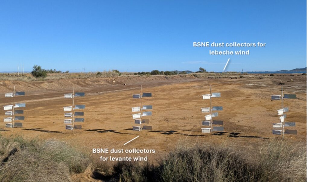
- Muestreo en los regímenes de viento dominantes (Lebeche – SO y Levante – E/NE) (Figura 12)
- Monitoreo estacional durante periodos de alto riesgo (verano y primavera)
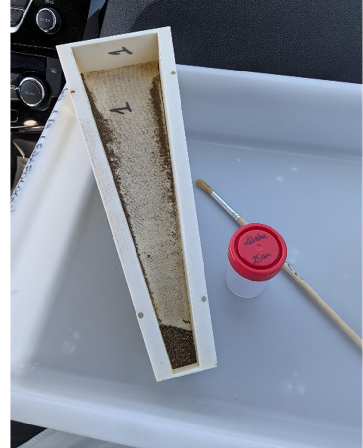
Figura 11. Colectores de polvo BSNE
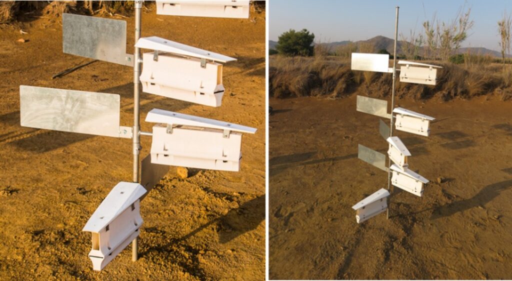
Figura 12. Colectores de polvo BSNE en la parte inferior de la Rambla del Beal.
Los resultados demuestran que la erosión eólica es un mecanismo importante para la dispersión de metales (Figura 13):
Figura 13. Recogida de muestras de polvo.
- Las partículas de polvo muestran concentraciones muy elevadas de metales (p. ej., Zn ~ 9500 mg/kg; Pb ~ 8000 mg/kg; Cu > 100 mg/kg-1)
- En la fracción de limo domina, lo que facilita el transporte a larga distancia
- La dirección del viento influye en ambos concentración y variabilidad de material transportado
Estos hallazgos confirman que las emisiones de polvo contaminante no solo representan un problema local, sino también un riesgo potencial a nivel regional y atmosférico.
De Datos de Campo a Modelado Predictivo
Un objetivo clave de SOILPROM es ir más allá de las observaciones específicas del sitio y desarrollar marcos de modelado integrados. Los datos de este caso de uso se proporcionarán a los modeladores de la Universidad de Wageningen para alimentar el modelo OpenLISEM (para simular la dispersión de metales por erosión hídrica) y el modelo MicroHH (para simular la dispersión de metales por erosión eólica). La integración de datos de campo y modelos ayudará a identificar vías de transporte críticas, cuantificar los flujos de contaminantes en diferentes escenarios ambientales y mejorar las predicciones del comportamiento de los contaminantes en condiciones climáticas cambiantes.
Se espera que estos procesos se intensifiquen bajo futuros escenarios climáticos caracterizados por períodos de sequía más prolongados y eventos de lluvia más extremos, particularmente en las regiones mediterráneas. Por lo tanto, comprender cómo la erosión inducida por el clima afecta la movilidad de los contaminantes es esencial para anticipar futuros riesgos ambientales y diseñar estrategias de mitigación efectivas.
Estrategias de remediación sostenible
Comprender cómo se mueven los metales y metaloides a través de este paisaje es esencial para diseñar medidas de mitigación y restauración efectivas.
Los resultados obtenidos en el caso de uso Cartagena–La Unión apoyarán estrategias de gestión del suelo basadas en evidencia, ayudarán a priorizar acciones de restauración como la estabilización de relaves y el establecimiento de vegetación, y contribuirán a reducir los riesgos de exposición ambiental y humana.
En un sentido más amplio, este caso de uso contribuye a la misión de SOILPROM de mejorar nuestra capacidad para evaluar y gestionar la contaminación del suelo en toda Europa mediante enfoques integrados y basados en procesos.